- Home
- History
- About
-
Houses
- Bassett Avenue Intro >
- Baychester Avenue Intro >
-
Boller Avenue Intro
>
- No Number Boller
- 2204 Boller
- 2207 Boller
- 2210 Boller
- 2211 Boller
- 2212 Boller
- 2219 Boller
- 2220 Boller
- 2221 Boller
- 2222 Boller
- 2223 Boller
- 2224 Boller
- 2225 Boller
- 2226 Boller
- 2227 Boller
- 2228 Boller
- 2229 Boller
- 2230 Boller
- 2231 Boller
- 2232 Boller
- 2233 Boller
- 2239 Boller
- 2295 Boller
- 2301 Boller
- 2302 Boller
- 2304 Boller
- 2305 Boller
- 2306 Boller
- 2308 Boller
- 2310 Boller
- 2312 Boller
- 2314 Boller
- 2319 Boller
- 2320 Boller
- 2322 Boller
- 2324 Boller
- 2325 Boller
- 2327 Boller
- 2329 Boller
- 2331 Boller
- 2339 Boller
- 2342 Boller
- 2361 Boller
- DeReimer Avenue Intro >
- Erskine Place >
-
Hunter Avenue Intro
>
- Barge Hunter
- No Number Hunter
- 2203 Hunter
- 2205 Hunter
- 2207 Hunter
- 2210 Hunter
- 2211 Hunter
- 2212 Hunter
- 2213 Hunter
- 2215 Hunter
- 2221 Hunter
- 2223 Hunter
- 2224 Hunter
- 2228 Hunter
- 2233 Hunter
- 2235 Hunter
- 2237 Hunter
- 2301 Hunter - old
- 2301 Hunter - new
- 2303 Hunter
- 2307 Hunter
- 2308 Hunter
- 2309 Hunter
- 2324 Hunter
- 2326 Hunter
- 2344 Hunter
- 2350 Hunter
- 2354 Hunter
-
Palmer Avenue Intro
>
- No Number Palmer
- 2195 Palmer
- 2198 Palmer
- 2200 Palmer
- 2201 Palmer
- 2202 Palmer
- 2204 Palmer
- 2205 Palmer
- 2206 Palmer
- 2209 Palmer
- 2211 Palmer
- 2215 Palmer
- 2220 Palmer
- 2230 Palmer
- 2232 Palmer
- 2234 Palmer
- 2306 Palmer
- 2310 Palmer
- 2311 Palmer
- 2312 Palmer
- 2313 Palmer
- 2314 Palmer
- 2319 Palmer
- 2321 Palmer
- 2323 Palmer
- 2324 Palmer
- 2335 Palmer
- 2336 Palmer
- 2337 Palmer
- 2338 Palmer
- Stillwell Avenue Intro >
- Wright Avenue >
- Across The Tracks
- Residents
- Businesses
- Maps
- Memories
- Contact
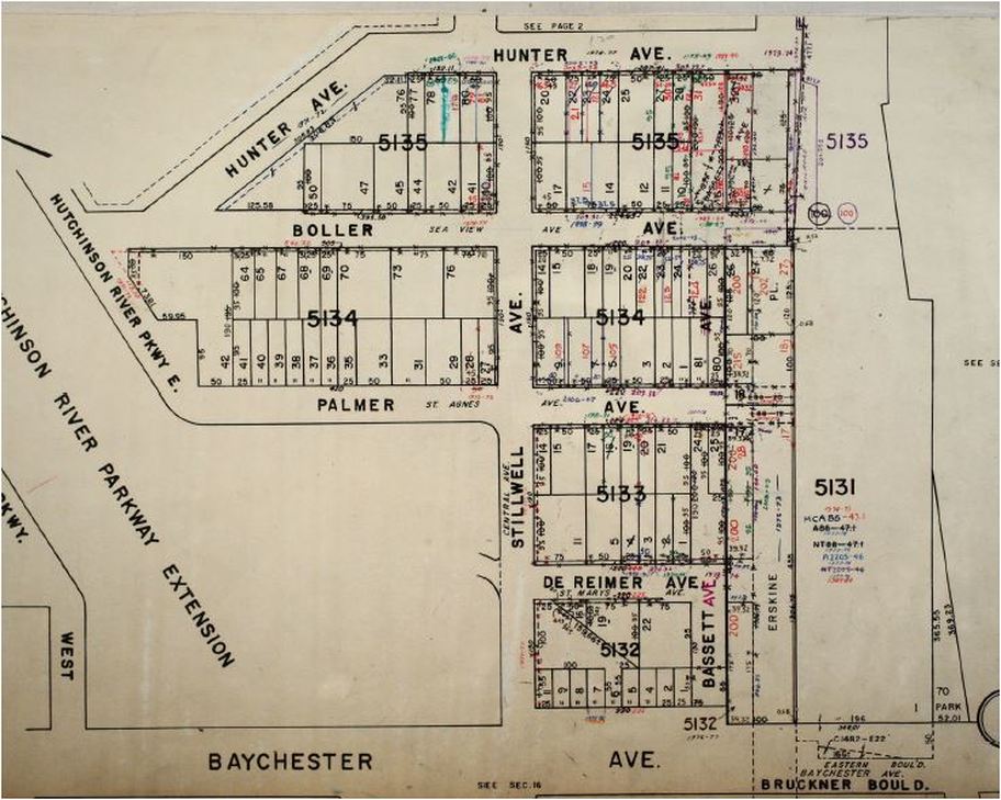
This is a Tax Map of the historic village after the Co-Op City rebuild. It identifies Block and Lot numbers. The Block Numbers include 5131, 5132, 5133, 5134, and 5135.
This map shows changes over time from 1971 through 2009. Each change is noted by year in a different pencil color.
Although Baychester Avenue is listed on the bottom of this map, at this time it no longer exists in this area. This portion of Baychester Avenue first became part of Bruckner Boulevard; it is now the New England Thruway directly behind this section of De Reimer Avenue. Off the page on the right is Pelham Bay Park.

- Home
- History
- About
-
Houses
- Bassett Avenue Intro >
- Baychester Avenue Intro >
-
Boller Avenue Intro
>
- No Number Boller
- 2204 Boller
- 2207 Boller
- 2210 Boller
- 2211 Boller
- 2212 Boller
- 2219 Boller
- 2220 Boller
- 2221 Boller
- 2222 Boller
- 2223 Boller
- 2224 Boller
- 2225 Boller
- 2226 Boller
- 2227 Boller
- 2228 Boller
- 2229 Boller
- 2230 Boller
- 2231 Boller
- 2232 Boller
- 2233 Boller
- 2239 Boller
- 2295 Boller
- 2301 Boller
- 2302 Boller
- 2304 Boller
- 2305 Boller
- 2306 Boller
- 2308 Boller
- 2310 Boller
- 2312 Boller
- 2314 Boller
- 2319 Boller
- 2320 Boller
- 2322 Boller
- 2324 Boller
- 2325 Boller
- 2327 Boller
- 2329 Boller
- 2331 Boller
- 2339 Boller
- 2342 Boller
- 2361 Boller
- DeReimer Avenue Intro >
- Erskine Place >
-
Hunter Avenue Intro
>
- Barge Hunter
- No Number Hunter
- 2203 Hunter
- 2205 Hunter
- 2207 Hunter
- 2210 Hunter
- 2211 Hunter
- 2212 Hunter
- 2213 Hunter
- 2215 Hunter
- 2221 Hunter
- 2223 Hunter
- 2224 Hunter
- 2228 Hunter
- 2233 Hunter
- 2235 Hunter
- 2237 Hunter
- 2301 Hunter - old
- 2301 Hunter - new
- 2303 Hunter
- 2307 Hunter
- 2308 Hunter
- 2309 Hunter
- 2324 Hunter
- 2326 Hunter
- 2344 Hunter
- 2350 Hunter
- 2354 Hunter
-
Palmer Avenue Intro
>
- No Number Palmer
- 2195 Palmer
- 2198 Palmer
- 2200 Palmer
- 2201 Palmer
- 2202 Palmer
- 2204 Palmer
- 2205 Palmer
- 2206 Palmer
- 2209 Palmer
- 2211 Palmer
- 2215 Palmer
- 2220 Palmer
- 2230 Palmer
- 2232 Palmer
- 2234 Palmer
- 2306 Palmer
- 2310 Palmer
- 2311 Palmer
- 2312 Palmer
- 2313 Palmer
- 2314 Palmer
- 2319 Palmer
- 2321 Palmer
- 2323 Palmer
- 2324 Palmer
- 2335 Palmer
- 2336 Palmer
- 2337 Palmer
- 2338 Palmer
- Stillwell Avenue Intro >
- Wright Avenue >
- Across The Tracks
- Residents
- Businesses
- Maps
- Memories
- Contact