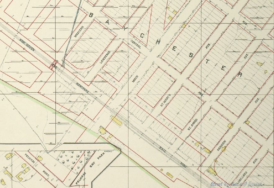
This is a Tax Planning Map of Baychester from 1905. This is a plan, not what really happened.......
Note that in 1918 the map was an actual map of the area, not the plan. So the place I call the "Village of Baychester" was really only Baychester Avenue between Bassett Avenue and Westchester Avenue, and only DeReimer Avenue and Palmer Avenue - 2 blocks by 2 blocks. Marshy areas and Given's Basin (part of the Hutchinson River) is all that existed in place of what eventually became Boller, Hunter, and Wright Avenues.
Map is from: https://digitalcollections.nypl.org/items/510d47e2-58e9-a3d9-e040-e00a18064a99
- The lower left-hand corner is PELHAM BAY PARK.
- Moving northeast toward the upper right-hand corner is the New Haven and Hartford Rail Road Tracks.
- If you look closely you'll see a yellow rectangle next to the train tracks between the park and the tracks - that's the original BAYCHESTER STATION.
- MAIN STREET became BAYCHESTER AVENUE.
- ST. MARY'S AVENUE became DE REIMER AVENUE.
- ST. AGNES AVENUE became PALMER AVENUE.
- SEAVIEW AVENUE became BOLLER AVENUE.
- LORILLARD AVENUE became HUNTER AVENUE.
- And we don't even see WRIGHT AVENUE.
- An undefined street became BASSETT AVENUE.
- CENTRAL AVENUE became STILLWELL AVENUE.
- WESTCHESTER AVENUE became part of the HUTCHINSON RIVER PARKWAY.
Note that in 1918 the map was an actual map of the area, not the plan. So the place I call the "Village of Baychester" was really only Baychester Avenue between Bassett Avenue and Westchester Avenue, and only DeReimer Avenue and Palmer Avenue - 2 blocks by 2 blocks. Marshy areas and Given's Basin (part of the Hutchinson River) is all that existed in place of what eventually became Boller, Hunter, and Wright Avenues.
Map is from: https://digitalcollections.nypl.org/items/510d47e2-58e9-a3d9-e040-e00a18064a99
Copyright ©Susan Vernon Kehr, 2020
